About
What is the I-95 Corridor Mobility Planning Project?
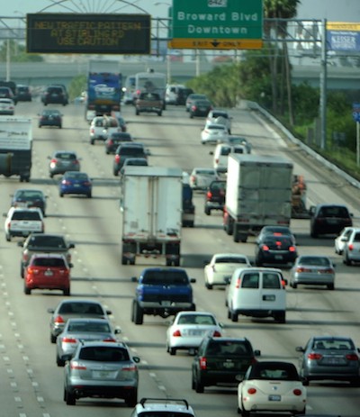
I-95 is the backbone of South Florida’s transportation system, and a critical resource for economic vitality. Daily congestion and crashes result in lost productivity and hinder the region’s ability to attract businesses and retain a skilled workforce.
Enhancing capacity on I-95 alone will not solve the problem. The solution rests in making it easier for people to access jobs, housing, education, goods, and services without driving on I-95.
The I-95 Corridor Mobility Planning Project is a holistic and integrated planning effort aimed at improving mobility in eastern Broward and southeastern Palm Beach Counties. While congestion on I-95 was the impetus for this effort, the project addresses broad issues of mobility and accessibility at a systems planning level, incorporating both land use and transportation together.
Working together, over 20 agency partners developed an Aspirational Future Vision Map that shows different transportation facilities and land use place types working as an integrated system.
The vision is expressed through a framework of facility types and place types, which recognizes that different transportation facilities serve different functions; different types of places serve different functions; and transportation and land uses together form a system of mobility and accessibility for South Floridians.
The vision map represents localities’ future land use plans, with transit-supportive land uses around future rail transit stations, and connected networks of multimodal and commerce corridors that provide access within and between these future multimodal districts and nodes.
Aspirational Future Vision Map
(click to enlarge)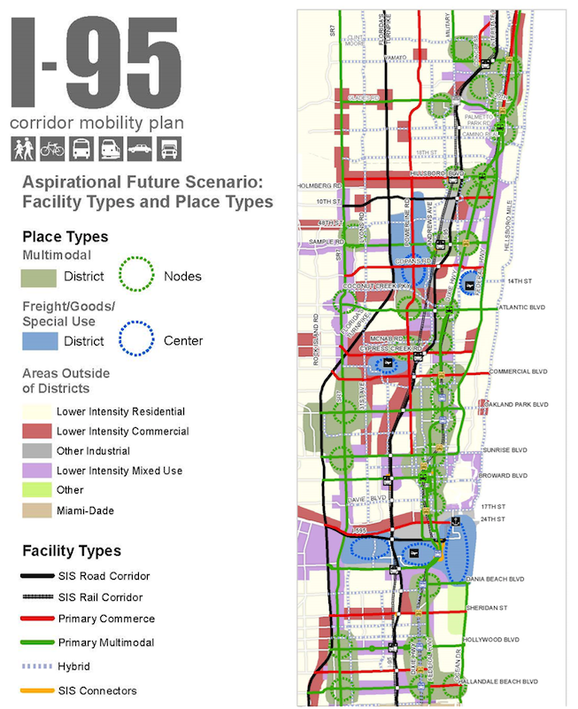
What are the Facility Types and Place Types?
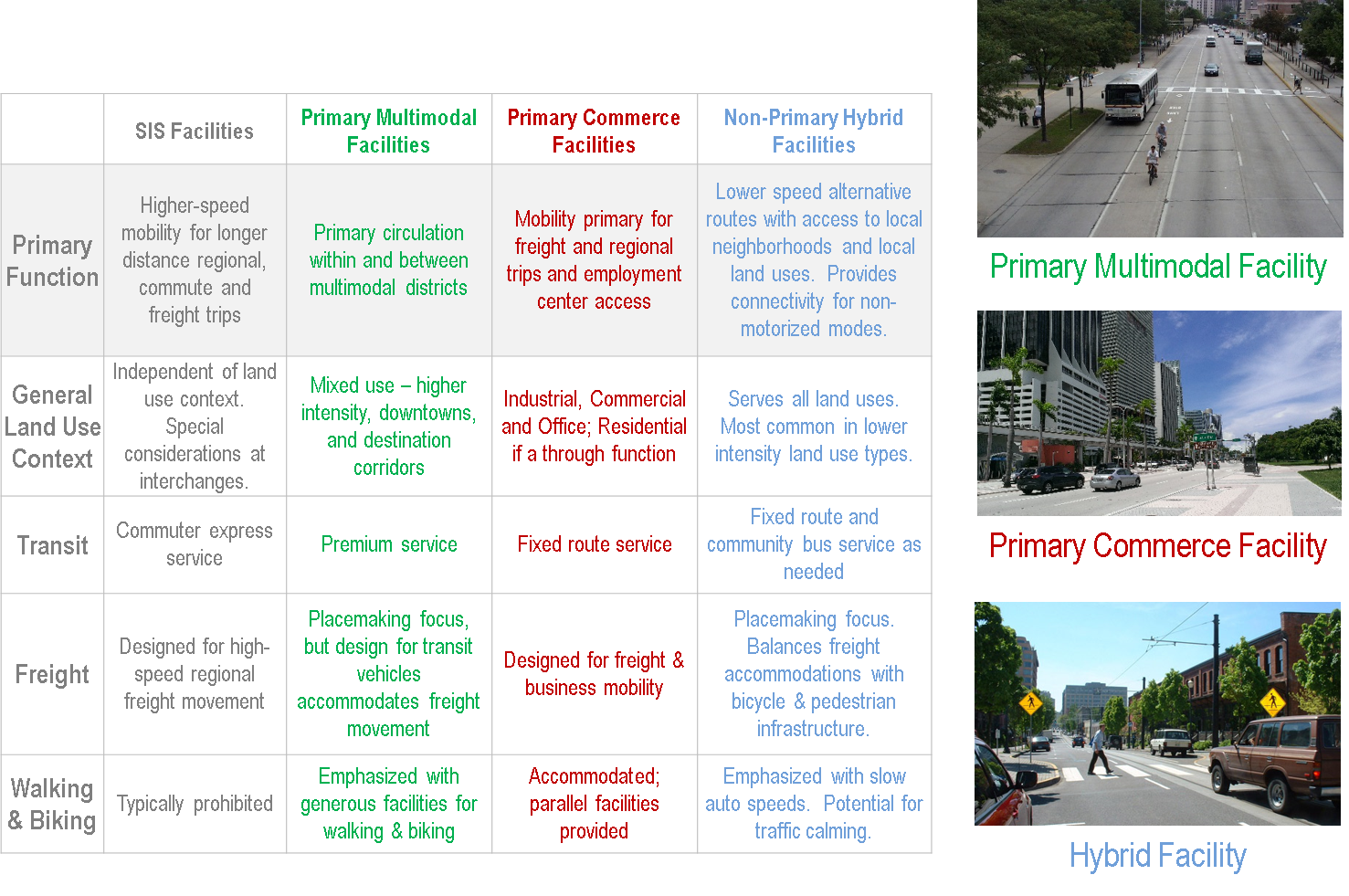
Facility Types
Transportation facilities were categorized into facility types based on generalized capacity and generalized future land use, and networks of transportation facilities were identified.
The categories and networks — Strategic Intermodal System, Primary Multi-modal, Primary Commerce, and Hybrid — serve different functions. The functions in the table below reflect the ideal functions of the facility types, recognizing that the designated facilities may not currently fulfill all of these functions.
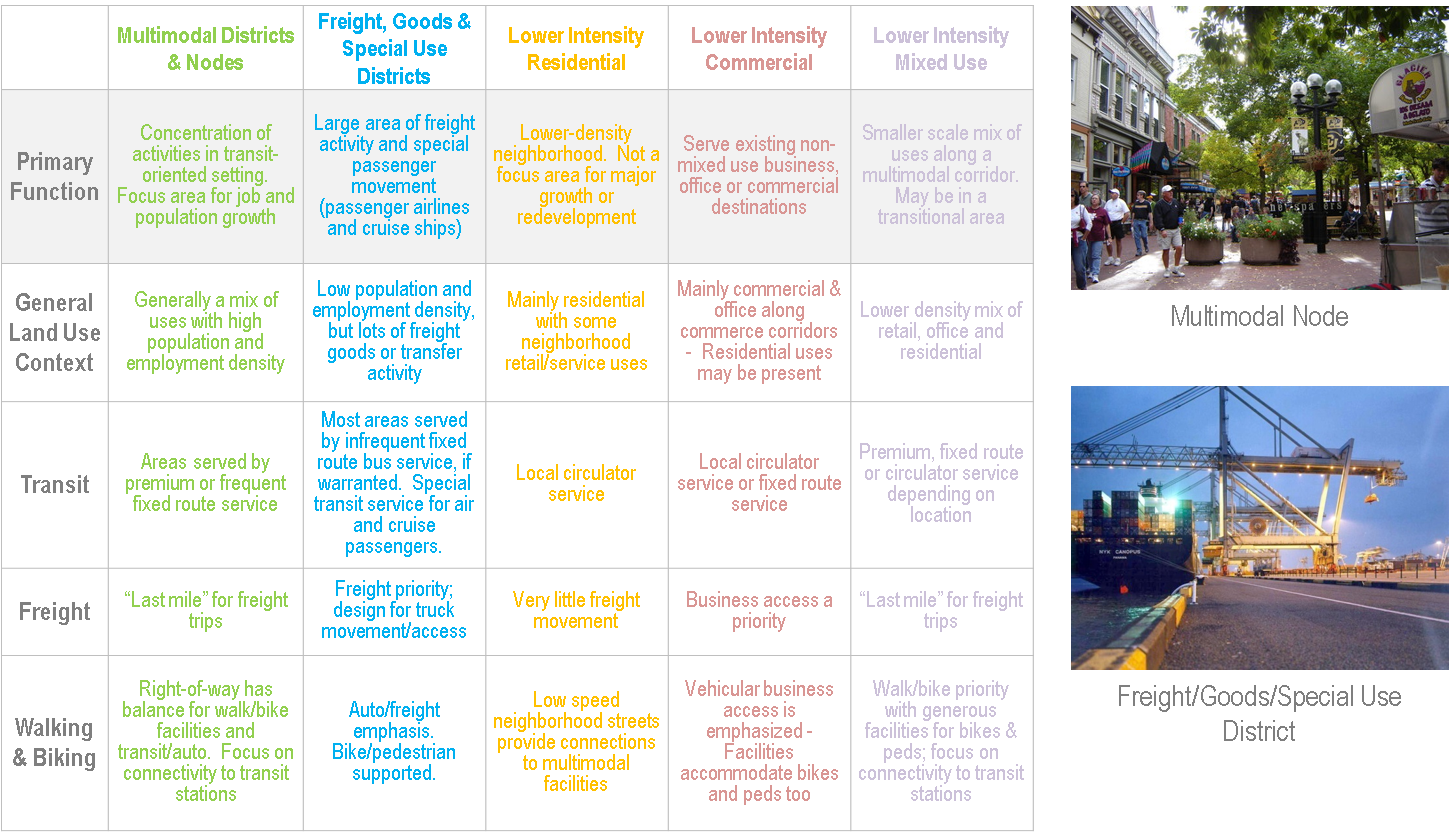
Place Types
Different types of places serve different functions. Quiet low density residential neighborhoods, bustling downtowns, office parks, big-box shopping areas, exurban retail and service corridors, ports, distribution centers, and airports, all function differently and depend on the transportation systems for different things.
By categorizing the areas within the study area into place types, we can recommend strategies for each of these types of areas that are specific to how they influence the transportation network. These strategies will help ensure that decisions about the built environment will be compatible to the function of the transportation network, and that the transportation network can best serve the built environment.
The functions below illustrate the ideal functions of the place types, recognizing that the designated places may not currently fulfill all of these functions.
Timeframe Definitions
The timeframes in the Tool are defined as follows:
- Past: This example has been completed and is no longer in effect - applies mainly to planning studies and construction projects that are not ongoing efforts.
- Current: The implementing agency has already implemented this example, and is currently employing it. Where the implementing agency is Cities, at least one city has begun to implement this example. This timeframe implies that there is an endpoint to the example.
- Future (timeframe unknown): This example has not yet been implemented, and the timeframe for which it could be implemented is unknown.
- Future (short-term): This example could potentially be implemented within five years, and would require either minimal funding or already has finding allocated for implementation.
- Future (mid-term): This example may not have a dedicated funding source, and may not be implemented within the next five years. Yet this example would likely require no significant policy changes and/or enabling legislation, and could be feasibly implemented within the next five to 10 years.
- Future (long-term): This example may require significant planning and environmental study, could require significant policy changes and/or enabling legislation, may lack a dedicated funding source, and is unlikely to be implemented within the next 10 years.
- Ongoing: This example is an effort that is currently underway, and will continue into the foreseeable future with no known end point.
What is this Web Tool?
This database contains the Implementation Strategies Tool — a compilation of over 100 strategies and 400 examples of initiatives, programs, and projects that all of the various planning partners in eastern Broward and southeastern Palm Beach Counties are undertaking in pursuit of an aspirational vision of mobility for the future transportation and land use system.
The strategies and examples in this tool represent both current and future strategies of transportation and land use planning agencies and local governments throughout eastern Broward and southeastern Palm Beach Counties, as voiced in a round of 20 listening sessions in the Fall of 2013. While not all of the strategies of all of the various planning partners may be documented here, this initial list represents a starting point for compiling all of the strategies in one place. It is intended to serve as a "living document." Each year, through the annual process outlined in the Monitoring and Evaluation Plan (found in Tech Memo #1: Executive Summary), FDOT will convene an annual summit where the planning partners will provide an update on their strategies and priority actions, and FDOT will revise this tool accordingly.